Thailand attracted $16.1 billion in realized high-technology manufacturing investment in the first half of the year, as multinational companies expanded production of AI components, printed circuit boards and data infrastructure in the Eastern Economic Corridor.
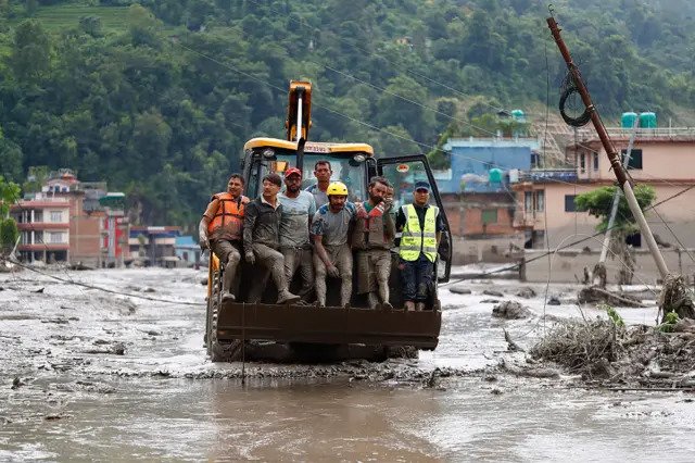
Scientists believe an enormous ice-rock avalanche blocked a Himalayan river before unleashing a fast-moving wall of water, mud and boulders across the border region.
A huge collapse of glacier ice and rock, rather than an earthquake, triggered the catastrophic flood that tore through communities along the Nepal-Tibet border, the strongest available seismic and satellite evidence indicates.
Scientists believe the avalanche struck the Lhende Khola, temporarily obstructed the river and released a violent surge into Nepal’s Bhote Koshi and Trishuli river systems.
The disaster struck on the morning of August 26, sending water, sediment and large boulders through steep Himalayan valleys with little warning.
At least 160 deaths had been confirmed across Nepal and Tibet by Thursday, while hundreds of residents, workers, pilgrims and foreign tourists remained unaccounted for.
The toll was expected to change as rescuers reached areas isolated by destroyed roads, bridges and communications.
The flood demolished homes, swept away vehicles and damaged hydropower facilities, monitoring stations and the strategically important border crossing between Nepal and China.
Nepalese authorities reported hundreds missing, including foreign nationals travelling through Rasuwa district toward Mount Kailash in Tibet.
Chinese authorities reported deaths and hundreds missing around Gyirong, the Tibetan county adjoining the border.
The disaster was initially confused with an earthquake.
The United States Geological Survey first registered shaking near the border as a magnitude 4.4 earthquake.
After examining long-period seismic waves and other data, it concluded that no earthquake had preceded the flood.
The signal was generated by the immense movement of ice, rock and debris itself and was subsequently assessed as equivalent to a magnitude 5.2 seismic event.
That distinction reverses the suspected chain of events.
An earthquake did not cause the mountainside to collapse; the collapse produced shaking powerful enough to resemble an earthquake on monitoring instruments.
The exact mechanism that converted the avalanche into such an enormous flood remains under investigation.
The leading explanation is that ice and rock plunged into the narrow Lhende Khola valley and blocked the river, allowing water and debris to accumulate behind a temporary natural dam.
When that obstruction failed, the impounded material rushed downstream as a dense, exceptionally destructive flood wave.
Scientists have not yet established how long the river was blocked, how much water accumulated or whether meltwater stored within or beneath the glacier contributed to the surge.
Field observations, higher-resolution satellite imagery and analysis of hydrological and seismic records will be needed to reconstruct the sequence conclusively.
Measurements farther downstream show the scale and speed of the event.
Preliminary hydrological observations indicated that the Trishuli River rose by as much as nine metres in approximately 30 minutes at Galchhi and by about seven metres at Malekhu.
Several monitoring stations were damaged or swept away, complicating efforts to track the flood in real time.
The lack of preceding heavy rainfall made the event especially difficult to anticipate using conventional flood-warning systems.
Unlike a monsoon flood that develops as rain accumulates across a river basin, an avalanche-generated surge can form high in the mountains and reach settlements within hours—or considerably less time in confined valleys.
Authorities were also monitoring debris remaining upstream because another blockage could retain water and then fail without warning.
Evacuations were ordered around the Gyirong border area, while downstream communities were warned to remain away from riverbanks.
Rescue work continued amid damaged transport links and concern over additional landslides.
Climate change cannot yet be identified as the direct cause of this particular collapse.
Establishing such a connection requires detailed evidence about the glacier, slope conditions, temperatures, precipitation and the physical failure that initiated the avalanche.
The wider risk, however, is well documented.
The Himalayas are warming rapidly, glaciers are losing mass, high-altitude lakes are expanding and thawing permafrost can weaken rock faces that were previously held together by ice.
More intense rainfall can further destabilize slopes.
These changes interact with the region’s steep terrain to produce cascading hazards in which a glacier or mountainside collapse becomes a river blockage, debris flow and destructive flood.
The Lhende Khola basin has now experienced two major floods within approximately 14 months.
The recurrence has intensified calls for Nepal and China to share satellite observations, river measurements and automated warnings across the border.
Investigators are continuing to analyse the remaining upstream blockage while authorities search for survivors and assess whether another sudden release threatens communities along the connected river system.
Scientists believe the avalanche struck the Lhende Khola, temporarily obstructed the river and released a violent surge into Nepal’s Bhote Koshi and Trishuli river systems.
The disaster struck on the morning of August 26, sending water, sediment and large boulders through steep Himalayan valleys with little warning.
At least 160 deaths had been confirmed across Nepal and Tibet by Thursday, while hundreds of residents, workers, pilgrims and foreign tourists remained unaccounted for.
The toll was expected to change as rescuers reached areas isolated by destroyed roads, bridges and communications.
The flood demolished homes, swept away vehicles and damaged hydropower facilities, monitoring stations and the strategically important border crossing between Nepal and China.
Nepalese authorities reported hundreds missing, including foreign nationals travelling through Rasuwa district toward Mount Kailash in Tibet.
Chinese authorities reported deaths and hundreds missing around Gyirong, the Tibetan county adjoining the border.
The disaster was initially confused with an earthquake.
The United States Geological Survey first registered shaking near the border as a magnitude 4.4 earthquake.
After examining long-period seismic waves and other data, it concluded that no earthquake had preceded the flood.
The signal was generated by the immense movement of ice, rock and debris itself and was subsequently assessed as equivalent to a magnitude 5.2 seismic event.
That distinction reverses the suspected chain of events.
An earthquake did not cause the mountainside to collapse; the collapse produced shaking powerful enough to resemble an earthquake on monitoring instruments.
The exact mechanism that converted the avalanche into such an enormous flood remains under investigation.
The leading explanation is that ice and rock plunged into the narrow Lhende Khola valley and blocked the river, allowing water and debris to accumulate behind a temporary natural dam.
When that obstruction failed, the impounded material rushed downstream as a dense, exceptionally destructive flood wave.
Scientists have not yet established how long the river was blocked, how much water accumulated or whether meltwater stored within or beneath the glacier contributed to the surge.
Field observations, higher-resolution satellite imagery and analysis of hydrological and seismic records will be needed to reconstruct the sequence conclusively.
Measurements farther downstream show the scale and speed of the event.
Preliminary hydrological observations indicated that the Trishuli River rose by as much as nine metres in approximately 30 minutes at Galchhi and by about seven metres at Malekhu.
Several monitoring stations were damaged or swept away, complicating efforts to track the flood in real time.
The lack of preceding heavy rainfall made the event especially difficult to anticipate using conventional flood-warning systems.
Unlike a monsoon flood that develops as rain accumulates across a river basin, an avalanche-generated surge can form high in the mountains and reach settlements within hours—or considerably less time in confined valleys.
Authorities were also monitoring debris remaining upstream because another blockage could retain water and then fail without warning.
Evacuations were ordered around the Gyirong border area, while downstream communities were warned to remain away from riverbanks.
Rescue work continued amid damaged transport links and concern over additional landslides.
Climate change cannot yet be identified as the direct cause of this particular collapse.
Establishing such a connection requires detailed evidence about the glacier, slope conditions, temperatures, precipitation and the physical failure that initiated the avalanche.
The wider risk, however, is well documented.
The Himalayas are warming rapidly, glaciers are losing mass, high-altitude lakes are expanding and thawing permafrost can weaken rock faces that were previously held together by ice.
More intense rainfall can further destabilize slopes.
These changes interact with the region’s steep terrain to produce cascading hazards in which a glacier or mountainside collapse becomes a river blockage, debris flow and destructive flood.
The Lhende Khola basin has now experienced two major floods within approximately 14 months.
The recurrence has intensified calls for Nepal and China to share satellite observations, river measurements and automated warnings across the border.
Investigators are continuing to analyse the remaining upstream blockage while authorities search for survivors and assess whether another sudden release threatens communities along the connected river system.
Glacier Collapse, Not Earthquake, Triggered Deadly Nepal-Tibet Flood
Swiss Tourist Sentenced to One Year in Prison for Insulting Bali's Sacred Day of Silence
Father Reprimanded After Leaving Seven-Year-Old Son Alone on Mount Fuji During Summit Climb
Google Launches Pixel 11 With Gemini AI at the Center of Its Hardware Strategy
China’s Kimi Launches AI-Focused Credit Card With Agricultural Bank of China and American Express
Success: Nvidia Turned Gaming Chips Into the Engine of the AI Boom
AI’s Next Bottleneck Is Power, Not Just Nvidia Chips
Meta Raises AI Spending Target to as Much as $145bn Despite Pressure Over Returns
Joe Biden’s Cancer Has Spread Beyond His Bones, Hunter Biden Says
Why 2027 Could Be a Strong Year for Stocks—and Why the Forecast Is Fragile
Why Markets May Look Quiet in August After Big Tech Earnings
UFO: Pentagon Releases Video of Unidentified Object Tracked Over Middle East
Ukraine Tells Senate Republicans Its Drone War Offers a Blueprint for America
Weight-Loss Drug Boom Tests the Limits of Prescription Advertising Rules
Taiwan’s President Joins Wartime Command Drill as China Pressure Grows
Lightning Strike Kills Yala FC Player During Match in Southern Thailand
AI Is Remaking the US Economy, From GDP Growth to iPhone Prices
Indonesia’s Free School Meals Plan Has Been Hit by Poisoning, Corruption and Cuts
US and Japan Step In to Support the Yen in Rare Joint Intervention
FIFA’s Retreat Leaves a Larger Question Over Who Guards the Game
Valued at $109 Million: F-35B Fighter Jet Crashes in Southern California
US Says It Has Carried Out Heavy Strikes on Iran After Attempted Attacks on Its Forces
Over 24 Hours in the Air: Qantas Airbus Completes Record-Breaking Test Flight
Nvidia Reportedly Takes Vast Texas Data-Centre Lease to Underwrite AI Expansion
FIFA’s Private-Investment Plan for World Cup Rights Draws European Revolt
Following OpenAI's Cyberattack: 'Most Companies Still Do Not Understand What Is Coming'
OpenAI Sued After ChatGPT Allegedly Discouraged Emergency Care Before Near-Fatal Embolism
Miliband Sets Climate and International Law at Centre of UK Diplomacy
Trump Readies New Tariffs as Temporary Global Levy Nears Expiry
EU Imposes Record €550 Million Digital Services Fine on AliExpress
Between Deliveries, Wang Jibing Wrote His Way to China’s Literary Heights
Morgan Stanley Builds a Wall Street Lead in AI Infrastructure Finance
High Prices Push Coffee Drinkers Toward Whole Beans and Home Brewing
Trump Draws Boos and Podium Scrutiny at Spain’s World Cup Triumph
Spain Defeats Argentina in Extra Time to Win Second World Cup
Police Block Cockroach Janta Party’s March to Parliament as Education Protests Intensify
Singapore Considers Lower Taxes for Fund Managers as Hong Kong Intensifies Talent Contest
Proposed U.S.-Saudi Nuclear Pact Could Permit Limited Uranium Enrichment Under International Safeguards
Why Kentucky Fried Chicken Became KFC—and Why the False Explanations Persist
Ukrainian Drones Strike Wildberries Warehouses Deep Inside Russia
Reported CIA Mission Helped Clear the UAE’s Path to Advanced US AI Chips
Artificial Intelligence Capital Fuels Markets While Governments and Regulators Face Mounting Strategic Tests
China’s Moonshot’s Kimi K3 Narrows the Gap With Anthropic Through Scale, Openness and Lower Cost
Gold and Cash Seizure Puts Indonesia’s Senior Anti-Corruption Prosecutor Under Investigation
The Ledger Will Not Trust on Faith
Ukraine’s Leadership Rift Spills Into the Streets as Protesters Target Army Chief
The Ten World Cup Finals That Defined Football History
Smartphones Are Getting More Expensive, Sales Are Collapsing, and Even Apple Admits: "Prices Will Rise"
Leadership Change and Strategic Rivalry Redraw the Political Map
The AI Race Enters Its Infrastructure Era